UNB Wide Area Augmentation System Monitoring Station

The Department of Geodesy and Geomatics Engineering at the University of New Brunswick runs a continuously operating GPS receiver with Wide Area Augmentation System (WAAS) capability. This receiver, a NovAtel FlexPak SuperStar II, currently accesses the WAAS messages transmitted by the new Galaxy XV satellite. The receiver is fed by an AeroAntenna AT-575-70 pole-mount antenna (UNB Head Hall antennas; close-up).

All data from the receiver including raw pseudorange and carrier-phase measurements at 2 Hz rate and all WAAS messages are archived in daily files.

Until the end of March 2006, a CMC Electronics AllStar L1 receiver was used to log WAAS messages and receiver data.

With the AllStar receiver, we logged data from the Inmarsat Atlantic Ocean Region West (AOR-W) satellite. However, on 1 February 2006, AOR-W (Inmarsat 3-F4), began a move from longitude 54°W to 142°W which it reached by 1 April 2006. At its new location, the satellite is no longer visible from UNB. As a result, there was a hiatus in our WAAS monitoring between the end of March 2006 and 4 May 2006 when the new receiver capable of tracking the new GEOs (Intelsat Galaxy XV and Telesat Anik F1R) was installed. Two QuickTime animations have been created to show the AOR-W move: Movie 1, Movie 2.

Between 4 May 2006 and 11 July 2007, the UNB receiver tracked one of the new GEOs, either Galaxy XV or Anik F1R. On 11 July 2007, the receiver was set to track either satellite and has been consistently tracking Anik F1R, which provides the strongest signal to the receiver.

The visibility of the original WAAS GEO satellites as well as the new GEO satellites from anywhere in Canada or the northern U.S. can be determined from elevation-angle contour maps: AOR-W (54°W), AOR-W (142°W), POR (178°E), GEO3 (Intelsat (formerly PanAmSat) Galaxy XV - 133°W), GEO4 (Telesat Anik F1R - 107.3°W). The visibility of the AOR-E (15.5°W) EGNOS satellite from eastern North America can also be assessed. Note that valid EGNOS corrections for eastern North America are likely unavailable.

The status of the transmissions from Galaxy XV and Anik F1R is available on the William J. Hughes FAA Technical Center National Satellite Test Bed Web site: <http://www.nstb.tc.faa.gov/incoming/New_WAAS_Geo_Status.pdf>.


Ionospheric Grid Delays and Grid Ionospheric Vertical Errors

Each day, the WAAS ionospheric grid delay (IGD) values and the corresponding grid ionospheric vertical error (GIVE -- 99.9% probability level or 3.291 sigma) values are extracted from the archive file to generate plots of the IGD and GIVE values at each of the ionospheric grid points superimposed on coverage maps of eastern and western North America and eastern Alaska. An example of the plots is shown below.


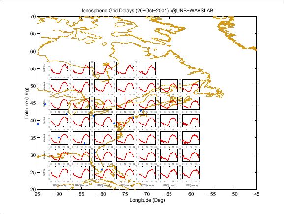
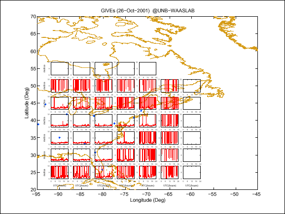
The blue dots indicate the locations of the current WAAS stations within the mapped area. IGD values for grid points on the periphery of the WAAS service area are noisy due to reduced satellite pierce point density. Note that the following peripheral grid points are not depicted on any of the maps: Furthermore, the grid points exclusively covered by the Pacific Ocean Region (POR) satellite are not included. These are the grid points at longitudes -180, -175, -170, -165, and -160 degrees covering western Alaska and the western Hawaiian Islands regions.

To see a map showing all of the ionospheric grid points for which vertical delays were provided by AOR-W and the corresponding GIVE coverage areas as well as the previously monitored points and coverage areas, click here. The dashed red line indicates the previous AOR-W GIVE coverage area. This map is no longer current.

Occasional gaps of some minutes or hours in the plots are due to data loss at UNB (power outages or other causes) or WAAS signal outages. Small gaps or breaks in the plots indicate that the interval between WAAS message IGD updates has exceeded 5 minutes. Occasional spikes in the IGD plots reflect IGD values of 63.875 metres in the WAAS message and are of unknown origin.

PDF files containing the plots of IGD or GIVE values for eastern North America since 28 July 2001 and for western North America and eastern Alaska since 28 April 2002, as obtained from AOR-W, and since 4 May 2006 from Galaxy XV and Anik F1R, may be downloaded by entering the date in the fields below:

Day:
Month:
Year:

East
West
Alaska

Ionospheric Grid Delays
Grid Ionospheric Vertical Errors


We have assembled the daily maps for eastern North America for the month of March 2002 into a QuickTime movie (double-click on the movie to replay it): The mid-latitude ionosphere was mostly well-behaved during March 2002 except for its response to a G1-G2 geomagnetic storm on 24 March following an M1 X-ray flare and associated halo CME on 22 March.


From time to time, we modify our archiving and map generation procedures. A list of changes to our system is available. This list also includes reports of gaps in our map archives.

For further information, please contact Hyunho Rho or Richard Langley.

The UNB WAAS-related research is supported by Nav Canada.

Updated 4 December 2007.